Реферат на тему:
Mount Everest - natural wonder
The ancient Sanskrit names for the mountain are Devgiri
(Sanskrit for "Holy Mountain") and Devadurga
(the English pronounced it deodungha
in the 1800s).[1]. In Nepali it is known as Sagarmatha
, meaning "Head of the Sky". The Tibetan name is Chomolungma
or Qomolangma
, meaning "Mother of the Universe"), and the related Chinese name is Zhūmùlngm Fēng
(Simplified Chinese: 珠穆朗玛峰; Traditional Chinese: 珠穆朗瑪峰) or Shèngm Fēng
(Simplified Chinese: 圣母峰; Traditional Chinese: 聖母峰).
In 1865, the mountain was given its English name by Andrew Waugh, the Britishsurveyor-general of India. With both Nepal and Tibet closed to foreign travel, he wrote:
I was taught by my respected chief and predecessor, Colonel Sir George Everest to assign to every geographical object its true local or native appellation. But here is a mountain, most probably the highest in the world, without any local name that we can discover, whose native appellation, if it has any, will not very likely be ascertained before we are allowed to penetrate into Nepal. In the meantime the privilege as well as the duty devolves on me to assign…a name whereby it may be known among citizens and geographers and become a household word among civilized nations.
Waugh chose to name the mountain after George Everest, first using the spelling Mont Everest
, and then Mount Everest
. However, the modern pronunciation of Everest: is in fact different from Sir George's own pronunciation of his surname, which was(EAVE-rest).
In the early 1960s, the Nepalese government realized that Mount Everest had no Nepalese name. This was because the mountain was not known and named in ethnic Nepal (that is, the Kathmandu valley and surrounding areas). The government set out to find a name for the mountain (the Sherpa/Tibetan name Chomolangma
was not acceptable, as it would have been against the idea of unification (Nepalization) of the country. The name Sagarmatha
was thus invented by Baburam Acharya.
In 2002, the Chinese People's Daily
newspaper published an article making a case against the continued use of the English name for the mountain in the Western world, insisting that it should be referred to by its Tibetan name. The newspaper argued that the Chinese name preceded the English one, as Mount Qomolangma was marked on a Chinese map more than 280 years ago.[4]
Measurement

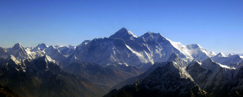
Aerial view of Mount Everest from the south

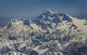
Another aerial view of Mount Everest from the south
Radhanath Sikdar, an Indian mathematician and surveyor from Bengal, was the first to identify Everest as the world's highest peak in 1852, using trigonometric calculations based on measurements of "Peak XV" (as it was then known) made with theodolites from 240 km (150 miles) away in India. Measurement could not be made from closer due to a lack of access to Nepal. "Peak XV" was found to be exactly 29,000 feet (8,839 m) high, but was publicly declared to be 29,002 feet (8,840 m). The arbitrary addition of 2 feet (0.6 m) was to avoid the impression that an exact height of 29,000 feet was nothing more than a rounded estimate.
Реклама

More recently, the mountain has been found to be 8,848 m (29,028 feet) high, although there is some variation in the measurements. The mountain K2 comes in second at 8,611 m (28,251 feet) high. On May 22, 2005, the People's Republic of China's Everest Expedition Team ascended to the top of the mountain. After several months' complicated measurement and calculation, on October 9, 2005, the PRC's State Bureau of Surveying and Mapping officially announced the height of Everest as 8,844.43 m ± 0.21 m (29,017.16 ± 0.69 ft). They claimed it was the most accurate measurement to date.[5]
But this new height is based on the actual highest point of rock and not on the snow and ice that sits on top of that rock on the summit, so, in keeping with the practice used on Mont Blanc and Khan Tangiri Shyngy, it is not shown here. The Chinese also measured a snow/ice depth of 3.5 m,[6]
which implies agreement with a net elevation of 8,848 m. But in reality the snow and ice thickness varies, making a definitive height of the snow cap, and hence the precise height attained by summiteers without sophisticated GPS, impossible to determine.
The elevation of 8,848 m (29,028 ft) was first determined by an Indian survey in 1955, made closer to the mountain, also using theodolites. It was subsequently reaffirmed by a 1975 Chinese measurement.[7]
In both cases the snow cap, not the rock head, was measured. In May 1999 an American Everest Expedition, directed by Bradford Washburn, anchored a GPS unit into the highest bedrock. A rock head elevation of 8,850 m (29,035 feet), and a snow/ice elevation 1 m (3 ft) higher, were obtained via this device.[8]
Although it has not been officially recognized by Nepal,[9]
this figure is widely quoted. Geoid uncertainty casts doubt upon the accuracy claimed by both the 1999 and 2005 surveys.
A detailed photogrammetric map (at a scale of 1:50,000) of the Khumbu region, including the south side of Mount Everest, was made by Erwin Schneider as part of the 1955 International Himalayan Expedition, which also attempted Lhotse. An even more detailed topographic map of the Everest area was made in the late 1980s under the direction of Bradford Washburn, using extensive aerial photography.
Реклама

It is thought that the plate tectonics of the area are adding to the height and moving the summit north-eastwards. Two accounts,[8]
[10]
suggest the rates of change are 4 mm per year (upwards) 3-6 mm per year (northeastwards), but another account mentions more lateral movement (27 mm),[11]
and even shrinkage has been suggested.[12]
Everest is the mountain whose summit attains the greatest distance above sea level. Two other mountains are sometimes claimed as alternative "tallest mountains on Earth". Mauna Kea in Hawaii is tallest when measured from its base; it rises over 10,203 m (about 6.3 mi) when measured from its base on the mid-ocean floor, but only attains 4,205 m (13,796 ft) above sea level. The summit of Chimborazo in Ecuador is 2,168 m (7,113 ft) farther from the Earth's centre (6,384.4 km or 3,967.1 mi) than that of Everest (6,382.3 km or 3,965.8 mi), because the Earth bulges at the Equator. However, Chimborazo attains a height of 6,267 m (20,561 ft) above sea level, and by this criterion it is not even the highest peak of the Andes.
The deepest spot in the ocean is deeper than Everest is high: the Challenger Deep, located in the Mariana Trench, is so deep that if Everest were to be placed into it there would be more than 2 km (1.25 mi) of water covering it.
The Mount Everest region, and the Himalayas in general, are thought to be experiencing ice-melt due to global warming.[13]
The exceptionally heavy southwest summer monsoon of 2005 is consistent with continued warming and augmented convective uplift on the Tibetan plateau to the north.[citation needed
]
Climbing routes
This section does not adequately cite its
references or sources
.
Please help improve this article by adding citations to reliable sources. (help, get involved!)
This article has been tagged since December 2006
.


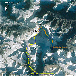
View from space showing South Col route and North Col/Ridge route


Southern and northern climbing routes as seen from the International Space Station.
Most attempts are made during April and May before the summer monsoon season. A change in the jet stream at this time of year reduces the average wind speeds high on the mountain. While attempts are sometimes made after the monsoons in September and October, the additional snow deposited by the monsoons and the less stable weather patterns makes climbing more difficult.
|